


Rawcliffe Meadows, 25 March 2019
Previously, before I had quite a lengthy summer break, we were looking at a phone box on Bootham. From there, heading out of town on the same road, we pass Clifton Green, and we’re on Shipton Road. We pass an entrance to Homestead Park, and to our left is increasing greenery, including Clifton Park, Clifton Ings, Rawcliffe Ings, and an area known as Rawcliffe Meadows. Beyond them is the River Ouse. A much-used Sustrans cycle/pedestrian route cuts through the meadows and the ings.
In this area of the ings are flood banks — barrier banks — built up in the late 20th century to try to contain and control the Ouse when it floods. There’s one close to the river’s edge, and another some distance away running through Rawcliffe Meadows.
The ings and the meadows here are part of my local patch, and through the course of more than a couple of decades living in the Clifton area I’ve walked and cycled through this precious landscape many times. Its preciousness wasn’t immediately obvious to me, as a younger person, but over the years the various details of it, observing the place over the years and the changing seasons, makes a more coherent picture, of its parts and its growth and its boundaries.
Anyway … I can’t go getting all lyrical and sentimental about it, because I’ve got to write a piece I’ve been trying to get together for some months, since I realised that the Environment Agency’s work to alter the flood defences also included this area, and involved quite a lot of environmental change/damage/destruction.
This has had some coverage, but not much. I wonder if it will get a lot more coverage when the many users of the cycle track and the many people who walk in Rawcliffe Meadows and the ings see the tree felling, and the works compound on the cornfield, and the removal of historic hedges and boundary walls. Probably later, in summers to come, people who pass through here will wonder why the wildflowers they used to see every summer are absent from the places they used to be. But it’s about much more than pretty wildflowers.
The planning applications to decide whether this work takes place are due to be decided by the planning committee on Thursday 12 September 2019. The scheme is recommended for approval. There are two applications, one for the barrier bank work and one for an access road into it.
Having looked at and absorbed as much of the information as I can, and having started reading it with as open a mind as possible, I have to say that the impact of the proposed scheme looks pretty disastrous to me, and it’s all quite depressing, though clearly the homes at the northern end of this area on and around Shipton Road need to be protected, after residents there have endured the trauma of their houses flooding in the past.
Flooding in York, as we know, has had devastating consequences for so many households, and businesses, so it would be difficult for councillors to vote against something that is being promoted as the way to protect the properties in the area. On the other hand, this proposed scheme is so environmentally damaging on so many levels.
A recent article in the local press, headed ‘Major York flood defence work delayed – by council planning process‘, seemed to be suggesting that something plainly entirely good and beneficial offered by the Environment Agency was being held up by the city council’s planning department being a bit slow/slack/rubbish. As I see it, the planning system is responding exactly as it should, taking time to gather the detail most of us don’t think about. Having looked at the further detail more closely I wish they’d delay it a bit longer. I don’t think most people realise what the impact of this is going to be over a large area.
There was so much complex detail that I couldn’t tackle it earlier as I didn’t know where to start. Thank goodness for the officer reports, summarising it. (On this link and this link.) Even then, these documents are quite long, and took a long time to read. I had to keep pausing and going off to do other things to keep it in perspective, as personally I found it a difficult read, realising what will be destroyed to raise and extend a flood bank.
I thought I’d include extracts from the officer reports that I found particularly striking. Many of them include the abbreviations SSSI – Site of Special Scientific Interest and SINC – Site of Importance for Nature Conservation. All these acronyms can be a bit alienating, but please don’t give up yet – we’re talking about a wildlife-rich area containing several different types of habitat, carefully managed and enhanced by many volunteers over many years. It’s described well in the officer report:
An ecologically high quality site is a product of living elements and their care, management and development over time. The use of the site by visiting wildlife is something to which wildlife becomes habituated over time.
We seem to have come to a time when all that is to be disturbed and damaged.
Officer’s opinion is that there will be a significant effect at a National level in the long term from the loss of SSSI habitat. There is uncertainty in the success of habitat creation and restoration, with time taken to reach target condition in the tens
of years (20-30yrs+), and only then with long term effort in management and monitoring… There will be a permanent loss of 0.9ha of SSSI through the enlargement of the flood bank
… The 25.13ha of MG4 grassland in Clifton Ings and Rawcliffe Meadows SSSI is 1.67% of the National resource. The proposed development would have a permanent impact on approximately 2.3ha of the SSSI. It would be exceptional for the Local Planning Authority to permit such harm
The area affected includes not just the obvious part of the flood bank in the open meadowland where the cycle track is, but everything alongside the existing barrier bank and a large area continuing on from that in both directions, up to the Rawcliffe country park and into Homestead Park in the other direction. An area inhabited by many creatures, great and small, particularly in and around Rawcliffe Meadows.
… The SINC supports a medium breeding population of Great Crested Newts across several small ponds and scrapes. There will be disturbance and temporary loss to terrestrial habitat within 500m of breeding ponds.
… Using Natural England’s rapid risk assessment tool as a guide it is likely that works will result in wildlife offences and therefore works will have to be carried out under a European Protected Species Licence
… Trenches and other excavations should be backfilled before nightfall, or a ramp installed to allow amphibians and other fauna that may enter the excavations to easily exit.
As mentioned above, the work also requires an access road and a site compound, which involves another area of habitat destruction.
… The proposed works (access road and site compound) will result in the temporary loss of habitat for and disturbance to a range of protected and notable species.
… As well as farmland birds, there will be the temporary loss of habitat and disturbance for a range of other species including Roe Deer, Toads, Barn Owls, and Hedgehogs.
So that gives us some idea of the impact on the SSSI, and some of the creatures it supports. Perhaps most of us don’t fully understand the value of the SSSI, and most of us won’t have seen the larger mammals that inhabit the area (though regular visitors may have noticed foxes, quite often). But I think we all notice when trees are felled, and perhaps when hedges are removed. There’s going to be a fair bit of that kind of thing too.
… The new access will be approximately 26m wide where it ties into Shipton Road and will require a length of hedge to be removed.
That’s a hedge next to the main road, so perhaps that won’t be seen as too bad. But that’s just part of it.
Hedgerow and tree removal would occur, in particular where the embankment would run through the cornfield, along the general extent of the existing barrier (which is to be removed) and where the southern extension is proposed. The EA
have advised that works will be adjusted on site where possible to avoid loss and the impact as shown on the Tree Plan drawings are worse case scenario. This worse case scenario includes a significant length of mature native species
hedgerow alongside Clifton Park that it may not be possible to replant. The tree plans show approx 60 individual trees plus groups of trees will possibly have to be removed.
(Bold emphasis added to the above.)
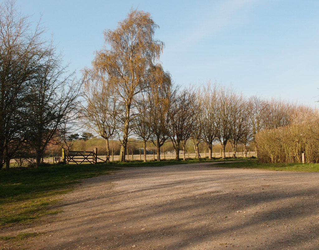
Gate to the cornfield, site of the proposed access road and site compound
The area sounds like it will be barely recognisable in places, doesn’t it, once this work is underway.
There are other aspects that perhaps only seem like a loss to those of us who’ve got to know the place over many years. A characterful section of brick wall and old hedgerow mark one of the boundaries of the old Clifton Hospital site, and because they’re just inside the ‘dry side’ of the existing barrier bank they’re going to be removed too, thereby removing part of the landscape character and its history.
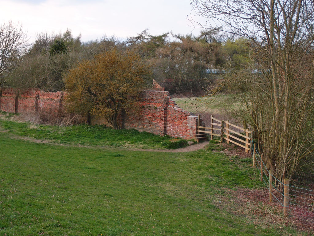
19th century brick wall, former boundary to Clifton Park Hospital
A report on the ‘cultural heritage’ of the area states:
Groundworks for the proposed raising of the Barrier Bank could impact on two areas of nondesignated ridge and furrow earthworks and a 19th century boundary wall associated with the former Clifton Hospital.
and states that:
The Scheme would not significantly alter the character of the historic landscape or how it is understood.
I disagree. Perhaps it’s only when you’ve lived near a place and walked through it and looked at it closely for decades in different light and at different times of day that you feel a connection to aspects of its heritage and understand their cultural importance. And also appreciate their quiet beauty.
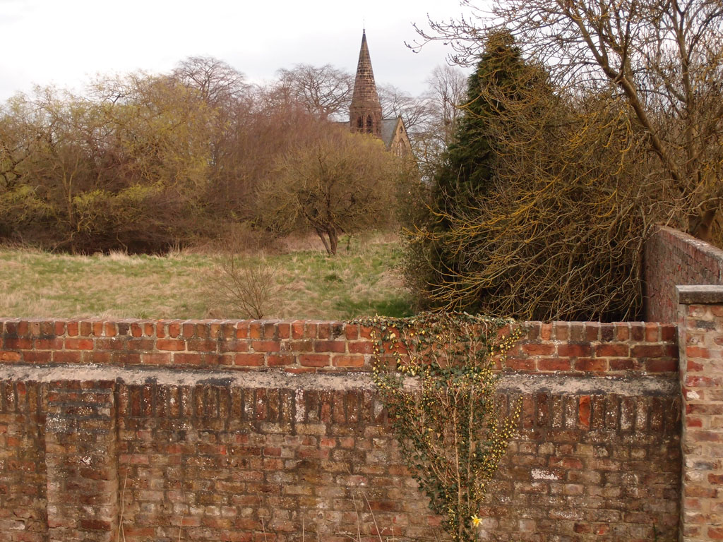
Former boundary to Clifton Park Hospital, and the hospital’s chapel, April 2015
About 15 years ago when I first walked through Rawcliffe Meadows with a digital camera I was rather fascinated by that picturesque and characterful brick wall, and wondered about its significance. Once I recognised its significance I was glad it had been retained. It reminds me of the orchards of the former hospital.
It took me a while longer to recognise and appreciate the ridge and furrow remnant near Blue Beck.
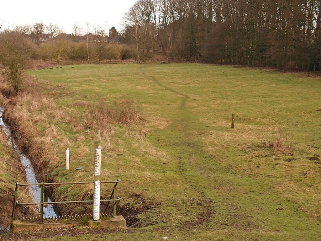
Remnant of ridge and furrow near Blue Beck, Jan 2017
Homestead Park
It’s not just about the meadows and ings. The extension of the flood bank will affect other much-valued places alongside. Particularly worrying is the proposed work through part of Homestead Park, which risks ruining the wilder section of this much-loved park, but has presumably been agreed to by the Joseph Rowntree Trust. There’s no comment by them on the planning portal, and very little detail I could find, except that it presumably involves cutting down some trees. The plan for this area includes the suggestion
Any felled logs could be retained on site and carved as sculpture, seating or play features
— it’s not logs that are felled, is it, it’s trees, which then become logs. As I recall there’s no shortage of logs in that area, but we may soon be lamenting our shortage of trees.
The Design and Access Statement (PDF here) includes towards the end details of how many vehicle movements are expected and what these heavy lorries will be bringing.

Extract from the Design and Access Statement – construction related traffic
From the dates on the above, it appears that the Environment Agency thought that work would be well underway by now.
‘Compensatory habitat’
There are of course proposals to try to make good some of the damage done, particularly to the SSSI parts of the work area. As the officer report states, ‘the Environment Agency’s proposals include the last resort of compensatory habitat.’
The compensatory habitat will be delivered on land adjacent to the SSSI and owned by the Environment Agency, known as Rawcliffe Ings. Rawcliffe Ings is some 12ha in area and is in the north-west corner of the application site (between
Rawcliffe Park and Ride and Country Park and the river)
I’m no expert, but I don’t think you can just roll up a wildflower meadow like a carpet and lay it somewhere else. According to the report, the replacement will be achieved through ‘translocation of turves, green hay spreading and collected seeds’. I hope that will work, but it seems to be generally acknowledged that it will take a long long time to become something akin to what’s there now.
Why is it recommended for approval?
The officer’s report acknowledges that
The proposed extension to the barrier bank and the pumping station are both in NPPF terms “inappropriate development”
– and that with regard to the effect on a SSSI ‘it would be exceptional for the Local Planning Authority to permit such harm’.
All things considered then, one might wonder how this application then ends up being recommended for approval. As with all similar applications, harm and benefit is weighed up, and in this case, the officer report concludes that
The works are required due to issues with the stability of the existing bank and as part of a wider programme to improve flood defences throughout the city.
It outlines the ‘very special circumstances’ that lead to the recommendation to approve:
… the benefits of the scheme; managing and reducing flood risk are deemed to be very special circumstances which clearly outweigh the harm to the Green Belt and other identified harm and make the proposals acceptable in application of Green Belt policy.
…Approval is recommended because the proposed works will bring significant community benefit, by reducing flood risk to a considerable area.
Clearly, from the number of objections, many don’t agree and don’t see a significant community benefit in these proposals.
Though it appears it wouldn’t matter whether the planning committee approve it or not, as the report also reminds us that the Environment Agency has special powers.
The EA state that the bank needs repairs in any event and these would, if permission were not granted, be undertaken under the Reservoirs Act 1975 i.e. without planning permission.
So perhaps it just remains to send heartfelt thanks to the Friends of Rawcliffe Meadows for their work in this area over many decades.
I hope the end result of the Environment Agency’s work isn’t as devastating to the environment as it looks like it might be.
Thanks for reading this rather lengthy piece. Further information can be found in the links below.
. . . . .
I hope to write more frequently for these pages after my long summer break on gardening leave. After a day spent compiling the above, I would appreciate your virtual coffees even more than before. Thank you for your support of this long-running record of York and its changes.
. . . . .
Further information
Agenda for the planning committee meeting, which includes links to the officer reports quoted above
Friends of Rawcliffe Meadows website
Clifton Ings Barrier Bank – The Problem – from the Environment Agency
‘Rawcliffe was completely overlooked and constituents there feel neglected’ – MP Anne McIntosh on the floods in November 2000 and the effect on the Shipton Road area.