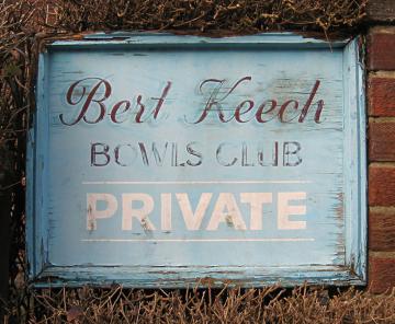
A piece in the Press recently highlighted that a decision is due this week on the Bert Keech bowling club site on Sycamore Place. I wrote about this bowling club a couple of years back, including a photo of its signs, as that was all I could see of the place.
There are more photos on the council’s website, on the relevant planning application pages. Many interesting documents are made available online with planning applications, and this one includes a report on the archaeology of the site. A site which apparently has a Roman road running through it. In the 19th century, when the area was first filled with housing, various interesting relics were unearthed in this area. So presumably there will be a full-scale archaeological excavation before anything is built here. Or perhaps we’ll rely on having the director of the CBA wander past at the right time …
Is this brownfield, perhaps? The city’s football ground was classed as such, a decade or so ago when Persimmon wanted to build on it. Even though it has a massive green area in the middle of it. When I say massive, I mean … well, the size of a football pitch. We often measure things in terms of x-number of football pitches, don’t we. Easy in that case. One football pitch.
Whereas the bowling club site obviously has a bowling green sized green space in the middle of it. Not massive, but big enough to fit a few houses on. And we need to find somewhere to put them. So no doubt it will be built on, just like so many other bowling greens.
It has been out of use for so many years now that it has fallen off the radar, or as the planning documents put it ‘it has not been an operational sports facility for over 5 years’. Any bowlers who did use it, or the other greens in the area (like the one behind the art gallery, also lost) have all moved to Clarence Gardens instead. Or perhaps just given up going bowling.
So the weed-filled old green is a totally unwanted bit of sports ground/green space.
But no, apparently not. The documents relating to the planning application suggest that St Olave’s School (with premises adjacent, in the old Queen Anne’s School buildings) or their senior school St Peter’s would like to take it over and use it for sports.
Is that likely? Well, no, it doesn’t seem to be, from what I can tell from the documents available.
The new houses will no doubt sell very quickly when built, because homes in this desirable residential area are in demand, partly I guess because of those nearby schools just mentioned.
If you look at the documents you’ll see that there are a lot of objections. Of course, you might say, there always are. Very few people welcome building sites. We all accept the need for new homes, but we don’t want them building near us.
There’s a vague general agreement that we should ‘build on the brownfield’ first, in already built-up areas, rather than on the outskirts, on the green belt, the green fields. But of course it was all fields once.
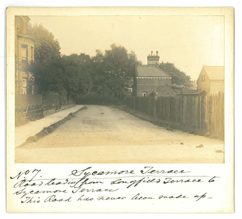
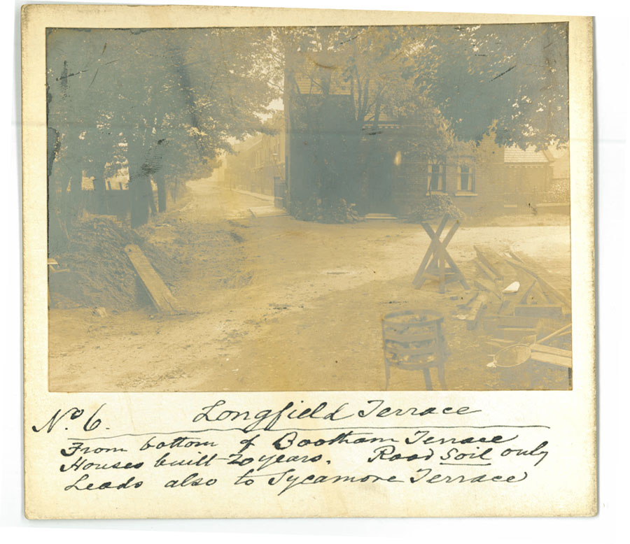
I happen to have, again from the Fairbank archive, a couple of photos from when the 19th century housing around here was itself quite new, as the captions make clear.
(Compare with: 2012 Google Street View of this scene)
Sycamore Terrace — now known as Sycamore Place (with Sycamore Terrace leading from it, to the right). The area since known as the Bert Keech Bowls Club would have been off to the left of this photo. As it was apparently established in 1912 it was perhaps there already when Mr Fairbank took this photo. Maybe he popped in for a game of bowls after he’d taken his photographs. Or maybe, as he lived just round the corner in St Mary’s, he popped back home for a spot of lunch.
The state of the roads was rather different then, as the caption makes clear. As does this one, from close by, near the other end of Sycamore Place, looking down Longfield Terrace.
(Compare with: 2012 Google Street View of this scene)
I’m assuming that Mr Fairbank was recording the state of the roads for professional purposes, rather than as a personal interest. He records that the road here is just soil. Sycamore Place is just off to the right. The railway line is to the left behind those trees. It appears that something is being built or constructed. Perhaps some better road surfacing.
He notes in his caption: ‘Houses built 20 years’. So quite new then.
Perhaps Mr Fairbank felt sad, in the 1890s, to see these long lines of buildings going up across the open land he’d known.
Now we refer to green areas being ‘concreted over’. I guess back then, as Victorian houses are as far as I know built on brick foundations, they wrote letters to the paper about their fields being ‘bricked over’.
Or did they? Perhaps they just accepted all these new houses as part of ‘progress’.
Should we do the same? Though how long before it gets too crowded? The Victorian era saw a lot of cramped housing being built. We pulled a lot of it down in the 1930s.
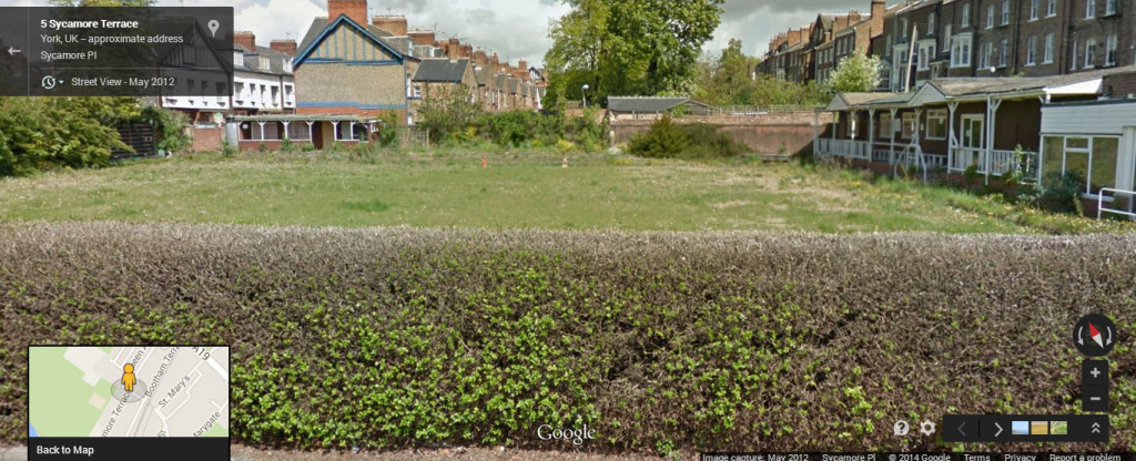
Google captures the demise of a green
When I include these old photos it seems a nice idea to if possible include the modern view, or a link to Google’s version of it if I’m too lazy to get up there myself. So I’ve done that via the links above. But while traversing this area via Google Street View I noticed that the Google car has captured something I couldn’t. And because it’s rather special I thought I’d grab the images, borrowing them from Google.
As you may have noticed, when using Street View, sometimes you’ll be in the middle of a street and you’ll be looking at an image from one year, then a few metres on you’ll be in a different year. When the Google car got to the end of Sycamore Place, in 2008, it captured the Bert Keech bowling green when it was still in use, and neat, with its clubhouse at the end, behind its neatly-trimmed hedge. (These images are enlargeable.)
And then four years later, and three months or so after I passed by and took the photo of its signs but couldn’t see over the hedge, the Google car came by again, and with its camera on the roof captured the wild weediness of the green, after the bowlers had left.
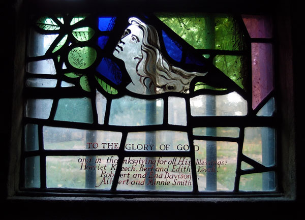
His green may soon be gone, but Bert Keech’s name is remembered in the stained glass window of the nearby church of St Olave. And here on these pages, in a lovely comment on the earlier page. And perhaps, imminently, in the form of a ‘Bert Keech Mews’, or maybe — following the example of the development called ‘Bootham Green’ at the former Shipton Street School — ‘Bert’s Green’?
Update
The planning application was approved, at the council meeting on 7 August.
The meeting was webcast and is available to watch now on YouTube. Handily, there’s a list on the page of the agenda items with a link to the start of the relevant section. If you’ve got time, it’s interesting to hear what councillors say about the application, particularly bearing in mind that they see and have to decide on many applications, and have a wider perspective.
I also want to include a comment from Marc who lives nearby. I asked him if he remembered the green in use. His words can close this page, and mark the end of this chapter, for this particular piece of land.
Page sponsored by a reader. Thank you.





The planning application was approved, just added an update above.
Although the Bowls club was founded in 1912 it was called Bootham Bowls Club & played on Exhibition Green, Marygate. It moved to Sycamore Terrace in 1949, replacing some redundant tennis courts. It was renamed the Bert Keech Club only after Bert’s early death in 1954