


AA sign on Bootham
Last Sunday, heading up Bootham towards the Gillygate junction, I thought I’d have a better look at the Lendal Bridge related signage, as so many visitors have complained about it. These photos represent the point of view of the motorist, well, almost, as I was in the passenger seat.
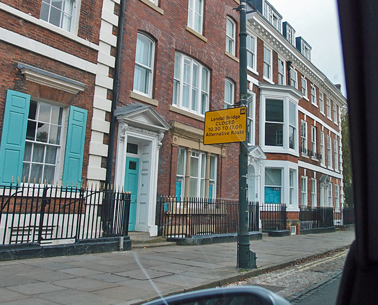
Here’s the AA sign on Bootham as you approach the city centre. It’s like the one pictured earlier, but the right way up and on a post. Is it helpful? No. Where is Lendal Bridge exactly? I guess I need to look it up on a map, or via my phone, but I’m driving. (Well, I’m not, I’m imagining being a visitor who is driving, and this involves having to imagine not only being able to drive, which I can’t, but being unfamiliar with the place, which I’m not, but I hope other Yorkies will join in this imaginary scenario.)
The photos are enlargeable. I’m sorry that they’re not very clear, as the car windows were dirty and the light was poor. Anyway, we’re moving up Bootham now as the lights have changed.
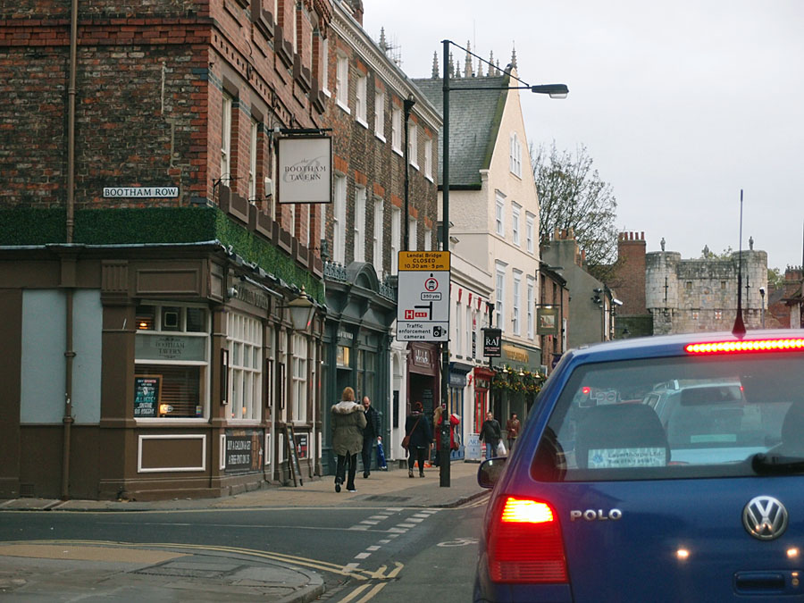
We’re now at the end of Bootham Row, right outside the Sainsbury’s Local, with Bootham Bar ahead and the Minster just visible over the rooftops on the left. One of my favourite views, which would be much nicer without the road signs intruding on the scene. But of course they’re a necessary thing. If they have to be there cluttering up the place then they should properly inform. Does this one?
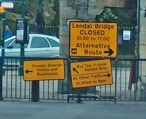
No. Again, where is this Lendal Bridge? Is it straight ahead? The yellow bit tells me about it, that it’s restricted, and the bit beneath appears to be pointing to it. There’s a right turn at the end of here too but it’s not on the sign. Cars and motorbikes not allowed to go straight on. I’ll go right then as I was planning to …
Is that how it is, if you’re a visitor?
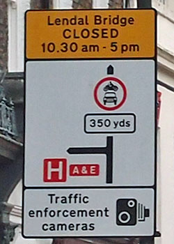
I know, because I live here, that if you turn right and turn right again you’re on Museum Street which leads to Lendal Bridge. I also know that the sign around the corner, on the front of the Theatre Royal, is very often obscured completely by the buses standing at the stop there. Visitors are unlikely to know either of these things.
We didn’t turn right, we turned left down Gillygate, and as we did I was startled by particularly silly signage, which I captured on camera (badly, blurrily) on the return journey.
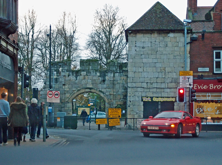
Top of Gillygate, at the lights, waiting to turn right into Bootham. This signage cluster looks particularly desperate. Looks like we now have five signs? One big one like that pictured above, and a couple to the left which I think must be connected (but I can’t read them on the blurry photo).
And between them this particularly desperate-looking cluster of yellow AA signs hung rather wonkily on the railings. It’s not often I feel embarrassed to be from York, but I was when I saw this ludicrous jumble. How much info are we expecting visitors to take in as they negotiate unfamiliar road junctions?
One of these signs, at last, seems to be presenting clear information. That one at the bottom in the stack of two. It does actually make sense, So why the one above it, and the others? The Minster Quarter sign is presumably necessary because the other signs are all discouraging us from going in that direction, and the businesses in the Minster Quarter want to remind us that they’re still there and accessible.
Someone please send Sir Ron Cooke and the ‘Reinvigorate York’ team to look at this street clutter ..?
How much money has been spent on these useless signs? They’re clearly useless, as so many visitors have been fined, as the Press reported recently.
And residents? How’s it been for us? Another story for another time I think. After all, this ‘trial’ is going on until February.
Comments welcome. If you have received a penalty notice you may be interested in this comment on the previous post.
Thanks for your ‘tourist eye’ view! My husband and I drove into York in November for the first time since 1973 from Bootham (A19) to Clifford’s Tower. After getting lost we ended up back at Bootham and consulted one of those roadside tourist maps – which took us over Lendal Bridge! My research has shown that as we drive a 12 seater minibus we’re actually allowed to use bus lanes (but we don’t intend to – never worth the potential hassle!) However, the PCN pics taken on Lendal Bridge show no bus markings – or any other signs apart from something that looks like a flattened elephant on the road. Surely this isn’t legal? It also seems that Lendal Bridge would require 2 bus lanes, 1 North and 1 South. As bikes are also allowed then the lanes need to be a minimum of 4 metres wide – which these certainly aren’t. Perhaps they plan on using the footpath to provide the extra width needed? I’d be interested in your feedback.
I know the signs have changed several times and been added to as problems came to light – not sure exactly what date you visited? Hope you’ve found the other sites and Facebook pages where the issue is being discussed as they can provide a lot of information I can’t. I’ll try on Twitter tomorrow to ask the City of York Council to answer your questions here.
We visited on November 17th, a Sunday. We’d intended to use the P&R, but my husband who has COPD (aspergillosis – mould growing in his lungs from bad working conditions)decided he needed to keep our minibus close so he could rest up when needed. We were actually picking up our daughter, but thought we’d do some sightseeing after our 60+ mile drive. I’d forgotten my map book, so we were scrutinising all the road signs to find our way to Clifford’s Tower. Having checked out my maps since, I realise we would have followed the inner ring road from Bootham, turned right onto Museum Street – which would have taken us unknowingly across Lendal Bridge – because maps don’t show bridge names. However, we would have crossed some 30 minutes earlier – around 10.15 rather than 10.45 – and would have known nothing at all about any of this.
As it happens, I’ve had a good trawl on the internet and found loads of very useful and informative info. I’ve also found this site, which I’m finding very interesting and helpful. I’ll certainly continue reading it.
Carol, I’m sorry this happened and hope that someone from the council has read your comment – I did ask on Twitter if they’d answer it, but clearly they haven’t. I’m glad you’ve found useful information on this site and others.
York Mix have had many articles on Lendal Bridge which I hope you’ve found – eg http://www.yorkmix.com/opinion/lendal-bridge-traffic-ban-city-centre-is-now-a-no-go-area/
On the signage issue: a photo I took recently of a more recent attempt to provide clear signage … https://twitter.com/YorkStories/status/410873856392302592/photo/1