


6 November 2006
It’s late autumn in York. The sun is low in the sky, the daylight hours are short, the leaves are turning and falling.
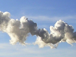
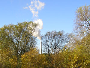
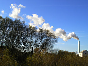
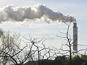
There’s another sign of autumn here. There’s not just a chill in the air now, but a pungent and familiar smell. Many hate it, but I love it. The unmistakeable odour from the sugar beet factory, near the side of the Ouse, between Acomb and Clifton. This chimney pumps out its emissions (mainly water vapour, apparently) with gusto, during each autumn/winter Campaign. This is the last year we’ll have the familiar factory smell in the autumn air. I still can’t believe it, but this is another factory that’s soon to close.
Its closure was announced months ago, and perhaps it’s daft, but I felt quite emotional about it. Perhaps it feels like too much is disappearing too fast around here.
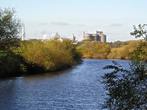
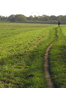
So rather than just stand on the back doorstep and smell the sugar beet smell in this last seasonal Campaign, I thought I’d pay the place a visit. Not as dull as it sounds – as the journey involved a marvellous energetic walk along Clifton Ings, on a sunny November morning. Starting here, at Clifton Bridge, where beyond the curve of the river there’s the admittedly not particularly beautiful factory, and its wonderfully odourful chimney.
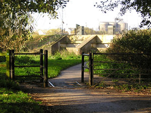
The concrete riverside path leads to a metal gate and cattle grid, and framed by trees and lit by the low morning sun, all this concrete ahead looks almost handsome. There’s a flood barrier here, and beyond it the great bulk of the factory. I’m trying to imagine what it will look like when these trees frame a view of yet more flats. When everywhere we look we see another block of flats. I think we’d better start preparing for this glorious apartment-filled future.
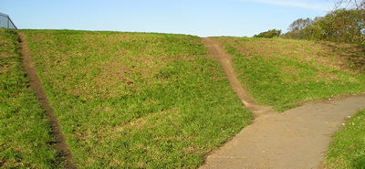
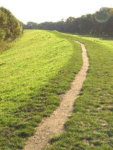
Here we are by the flood gates, where the concrete path/cycle track curves round this mound, bearing off to the right, a nice smooth surface for cyclists and walkers. But I love these paths here straight ahead, the kind that are made not by local authorities but by people’s feet. I’ve heard these called “desire lines”, because they show where people really want to go. And here, many have seen the path as unnecessarily curvy and a rather long-winded way to get onto the Ings, so they’ve just gone straight ahead up the slope.
I looked at this and thought of Robert Frost’s poem about the diverging roads: “…I took the one less travelled by, And that has made all the difference.”
Though it won’t make much difference here – unless you slip on the muddy incline.
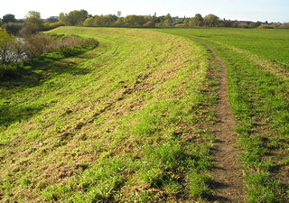
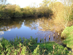
Once on the slope, I could see the flood plain stretching into misty morning greenness and blueness, and ahead this beautiful curve, where the flood bank follows the curve of the river.
I’ve walked along here once or twice before, but usually go the other way, towards Rawcliffe Meadow, and I’ve never seen it at this time of the year, with the sun so low, and so bright.
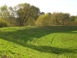
It’s the low light I guess that brings out the contours of the land. These are man-made contours, of course, part of the flood defences. The flood gate is opened when the river is high to let the flood water onto the flat land beyond this raised bank. Man-made or not, it’s visually very satisfying, and I’ve never noticed before.
On the horizon, as I rounded the curve, the waterworks at Acomb Landing just visible. This dates from the mid-nineteenth century, my research tells me. As you get close to it, you can hear dogs barking, as the RSPCA home is also here. And you can hear trains, as there’s a main line here on the other side the river.
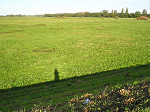
Have I mentioned before that I’m descended from many generations of railwaymen? . . . probably. Anyway, I always feel happy when I hear the sound of trains. Down here on the Ings it’s a strange mixture – a vast expanse of open land that makes you feel like you’re miles away from a city, but the noises of the city so obvious too.
Clifton Ings is an ancient flood meadow, recorded in the Domesday Book. During the medieval period, common rights of grazing saw the meadows opened to livestock around Lammas Day – 1 August. From this association the Ings were known as Lammas Lands. A romantic-sounding name, and one I think I’ll use in the future. I like the sound of “going for a walk in the Lammas Lands”.
Another interesting part of this area’s history is that the Ings were the official venue for York races, in 1709, until around 1730, when the tendency of the land to flood meant the races moved to the Knavesmire, where, of course, they’re still held.
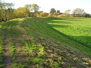
As the river straightens out again, the flood bank does too, and extends forward for a pleasing distance. Here we’re looking back towards the city. On the horizon, not very clear because it’s against the morning sun, the Yorkshire Wheel. An important Norwich Union sponsored contribution to our city’s leisure and tourism industry. Norwich Union have recently announced that they too are about to make lots of local people redundant. Never mind, eh, at least we’ve got a big wheel to go round and round on when we’re bored.
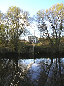
Looking across to the other side of the river, where our local sugar processing factory churns out its steam. I think these buildings are part of it – though I guess they could be part of the waterworks, but they looked rather beautiful, in a desolate kind of way, between the trees and reflected in the river. I started to notice the noise too – factory noise, and the passing trains still. Like things were happening – real, ordinary, everyday things.
Soon there will be other noises here – demolition, then the familiar noise of the building site. I do hope there are lots of people round here training for the construction industry.
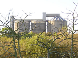
“York Sugar Factory, built in 1926, plays a major role in the prosperity of the area, as an employer ratepayer and a user of local services,” says the British Sugar website.
So it’s been there for 80 years, its landmark chimney pumping out that familiar smell. As children, we used to find the occasional sugar beet sometimes by the side of the road, where it had fallen from the passing lorries. It looked a bit like a potato, and covered still in a film of earth. We used to imagine that if we took it home to our mum she’d be able to boil it up in a pan and turn it into a bowl of sugar.
The numbers actually employed in the factory are quite small, but the knock-on effect of the imminent closure will be massive, particularly for the growers of sugar beet in the area. In reports I’ve read, the number of growers seems to vary widely from 790 to 1,500 – but even at the lower figure, that’s a vast impact in the region.
The most sickening thing with all these closures and job losses – the spin. The gloss they put on situations, in the press releases. I looked at the British Sugar website, to see what they’d said when they announced the closure of this factory and another in Shropshire. The headline? “Plans to ensure long term future of UK beet sugar industry announced”.
The company denied strongly that the closures were driven by the desire to make the most of high land values.
It’s difficult not to start ranting about the way things are going in this city, in terms of factory closures and redundancies. Maybe later. For now – I carried on walking along the floodbank.
Just up from the factory, the river looked as calm as ever, and the sunlight got warmer and as high as it was probably going to get on a day at this time of the year. Fishermen were sitting on the river bank.
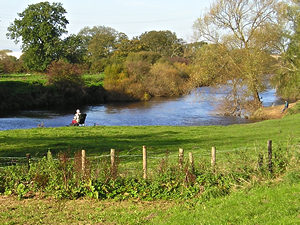
I turned right here, before I got as far as the bypass, which I could see ahead of me. Turning right takes you into the Rawcliffe Meadows area, where helpful signs provide information on the environmental management of the area and its wildlife. Another concrete cycle track/path leads you back towards Clifton. Or, if you prefer grass and earth under your feet, there’s a path here on top of another section of flood bank. I chose this one – the road less travelled – or at least, the route on which you’re less likely to get mown down by speedy cyclists.
For maps of this area, and more information, see the recently published Green Places Guide, available from local bookshops.
Background information
The Friends of Rawcliffe Meadows
“York staff are particularly incensed because the factory has won many awards for its environmental record and British Sugar gave a commitment to retain jobs less than six months ago.” British Sugar to shut two refineries – Guardian, 4 July 2006
– – – – –
Lisa @YorkStories
Thank you for adding a comment. Please note that comments are moderated, but should appear within 24 hours.